Israel Updates Southern Lebanon Security Zone Map in Strategic Signal Amid Rising Border Tensions
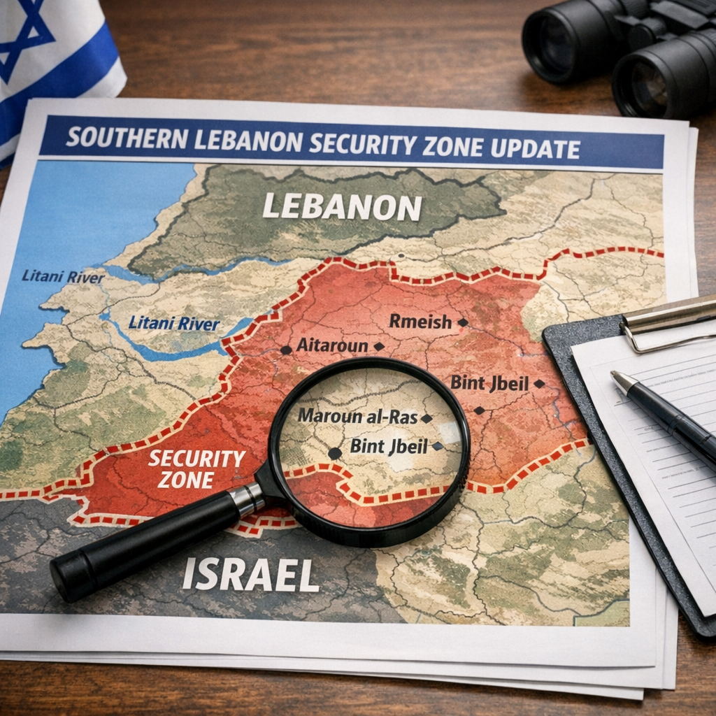
Israel’s military has released an updated map delineating its security zone in southern Lebanon, a move that underscores the continuing volatility along the Israel-Lebanon border and signals a recalibration of operational priorities in the area.
According to a report by i24NEWS, titled “IDF publishes updated map of security zone in southern Lebanon,” the newly issued map reflects the Israel Defense Forces’ current assessment of the terrain and threat environment near the frontier. The publication of such a map is seen as both a tactical clarification and a form of strategic messaging, aimed at signaling Israel’s red lines and reinforcing its monitoring posture in a region where tensions with Hezbollah remain persistently high.
The revised demarcation comes amid ongoing cross-border incidents and heightened vigilance following months of instability tied to the broader regional conflict dynamics. Israeli officials have repeatedly stated that their objective is to prevent Hezbollah from entrenching itself closer to the frontier, particularly in areas that could facilitate attacks on northern Israeli communities.
While the IDF has historically maintained a degree of ambiguity regarding specific operational zones in southern Lebanon, the decision to publicize an updated map suggests a shift toward greater transparency, potentially intended to deter militant activity by clearly outlining areas under heightened Israeli scrutiny. Analysts interpret this as part of a broader effort to manage escalation risks without triggering a full-scale confrontation.
The security zone concept itself carries historical weight. Israel previously maintained a buffer zone in southern Lebanon until its withdrawal in 2000, and any contemporary reference to such zones is politically sensitive, both domestically and internationally. Lebanese officials and Hezbollah have long rejected any suggestion of Israeli-controlled or influenced areas within Lebanese territory, viewing such measures as violations of sovereignty.
The updated map also emerges in the context of ongoing diplomatic efforts aimed at stabilizing the border, including discussions involving international mediators seeking to reinforce the terms of United Nations Security Council Resolution 1701. That resolution, which ended the 2006 war between Israel and Hezbollah, calls for the demilitarization of southern Lebanon south of the Litani River and the exclusive presence of Lebanese state forces and UN peacekeepers in the area. Israel has frequently accused Hezbollah of violating these terms.
By publishing the new map, Israel appears to be reinforcing its interpretation of the security landscape while signaling its expectations to both Hezbollah and international actors. Whether this step contributes to de-escalation or further entrenches tensions remains uncertain, but it highlights the fragile and closely watched nature of the Israel-Lebanon border at a time of broader regional instability.