Drones Target Weather Forecasting Blind Spots
A new generation of atmospheric drones is emerging as a potential answer to one of meteorology’s most persistent challenges: the lack of high-resolution data in the lowest layers of the atmosphere, where much of the weather that affects daily life actually forms.
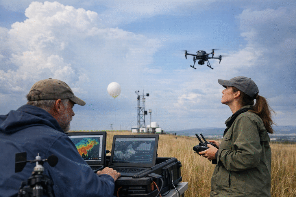
In a recent Wall Street Journal video, “The Drone Tech That Could Solve Weather Forecasting’s Biggest Blind Spots,” part of its Tech Behind series, researchers and engineers describe how autonomous aerial systems are beginning to fill critical gaps between ground-based sensors and traditional weather balloons. These gaps have long limited the precision of forecasts, particularly for fast-changing and localized events such as severe storms, heat waves, and sudden shifts in wind patterns.
Conventional tools offer only partial coverage. Weather balloons provide valuable vertical profiles of the atmosphere but are typically launched just twice a day and drift unpredictably with the wind. Ground stations, while continuous, are fixed in place and unable to capture vertical variability just tens or hundreds of meters above the surface. Radar and satellites, meanwhile, struggle to resolve fine-scale features in the lower atmosphere due to physical and technical constraints.
The drone systems highlighted by the Journal aim to bridge these limitations. Equipped with compact meteorological sensors, they can ascend and descend repeatedly through the boundary layer, collecting detailed measurements of temperature, humidity, pressure, and wind conditions in real time. Their ability to hover or follow programmed flight paths allows for targeted data collection in areas where conditions are rapidly evolving.
Researchers say this capability could significantly improve short-term forecasting models. Much of the uncertainty in weather prediction stems from incomplete or outdated initial data; more precise observations closer to the ground would allow models to better capture how storms develop, intensify, or dissipate. In particular, improved data could enhance warnings for severe weather events, where minutes can make a measurable difference in outcomes.
Beyond forecasting accuracy, the technology also points to a shift in how atmospheric data is gathered. Rather than relying on a sparse network of large, expensive systems, meteorology may increasingly depend on fleets of smaller, more flexible units that can be deployed on demand. Some developers envision autonomous networks of drones operating continuously, feeding live data into forecasting systems much like satellites do today, but at a far finer scale.
Challenges remain before widespread adoption becomes feasible. Airspace regulation, safety concerns, battery limitations, and operational costs all present hurdles. Ensuring consistent data quality across large numbers of devices is another obstacle, particularly if these systems are to be integrated into national or global forecasting models. There is also the question of scalability: deploying enough drones to meaningfully cover large regions would require substantial coordination and infrastructure.
Even so, early trials suggest the approach is promising. By capturing the dynamic conditions in the lowest part of the atmosphere—where people live, infrastructure operates, and weather impacts are most direct—drone-based sensing could reshape how meteorologists understand and predict the environment.
As the Wall Street Journal’s report underscores, the effort is less about replacing existing systems than about complementing them. The combination of satellites, radar, balloons, and now drones could offer a far more complete picture of the atmosphere, narrowing the “blind spots” that have long constrained forecasting—and potentially providing earlier, more accurate warnings in a world where extreme weather is becoming more frequent and more consequential.